


 SPLAT! analyze point-to-point terrestrial RF communication links.SPLAT! is a Surface Path Length And Terrain analysis application written for Linux and Unix workstations. SPLAT! analyzes point-to-point terrestrial RF communication links, and provides information useful to communication system designers and site engineers.
 SPLAT! is an RF Signal Propagation, Loss, And Terrain analysis tool for the spectrum between 20 MHz and 20 GHz.
Applications of SPLAT! include site engineering, wireless network design, amateur radio communications, frequency coordination, communication system design, and terrestrial analog and digital television and radio broadcasting.
SPLAT! provides site engineering data such as the great circle distances and bearings between sites, antenna elevation angles (uptilt), depression angles (downtilt), antenna height above mean sea level, antenna height above average terrain, bearings and distances to known obstructions based on U.S. Geological Survey and Space Shuttle Radar Topography Mission elevation data, path loss and field strength based on the Longley-Rice Irregular Terrain as well as the new Irregular Terrain With Obstructions (ITWOM v3.0) model, and minimum antenna height requirements needed to establish line-of-sight communication paths and Fresnel Zone clearances absent of obstructions due to terrain.
SPLAT! produces reports, graphs, and highly detailed and carefully annotated topographic maps depicting line-of-sight paths, path loss, field strength, and expected coverage areas of transmitters and repeater systems. When performing line-of-sight analysis in situations where multiple transmitter or repeater sites are employed, SPLAT! determines individual and mutual areas of coverage within the network specified. SPLAT! also produces .geo Georeference Information Files for interoperability with Xastir software, and .kml Keyhole Markup Language files for interoperability with Google Earth.
SPLAT! is free software. It may be redistributed and/or modified under the terms of the GNU General Public License Version 2 as published by the Free Software Foundation.

Download SPLAT!
Download Source Package for Ubuntu 11.04 “Natty Narwhal”:
Download Source Package for Ubuntu 11.10 “Oneiric Ocelot:”:
Download Source Package for Ubuntu 12.04 “Precise Pangolin”:
Download SPLAT! and associated data files for your area through the following links:
- SPLAT! Version 1.4.0 (splat-1.4.0.tar.bz2) (357k)
- SRTM-1 Version 2 Elevation Models (for use with SPLAT! HD v1.3.0 and later versions)
- SRTM-3 Version 2 Elevation Models (for use with SPLAT! v1.1.1 and later versions)
- 1 Degree USGS Digital Elevation Models By Name
- ARC/INFO Ungenerate (ASCII Format) Cartographic Boundary Files for County and County Equivalent Areas
- ARC/INFO Ungenerate (ASCII Format) Cartographic Boundary Files for Census Designated Places
Note that SPLAT! uses coordinates based on WGS-84 or NAD83 datum. Older NAD27 coordinates can be converted to NAD83 coordinates using an on-line conversion utility.
An excellent command-line utility capable of converting the Portable PixMap (PPM) topographic map files generated by SPLAT! into highly compressed Portable Network Graphics (PNG) files is wpng. wpng may be downloaded from the libpng.org web site.
Versions of SPLAT! that run under Windows have been made freely available by John McMellen, KC0FLR, and Austin Wright, VE3NCQ. A version of SPLAT! for the Mac has been made available by Glen Bizeau, VE9GLN.

SPLAT! News.
SPLAT! Version 1.4.0 was released on March 14, 2011. This release introduces a new contour smoothing feature (used to generate the graphic shown in Figure 1 below), introduces a color key overlay to GoogleEarth contour displays, and supplants the Longley-Rice propagation model with a new Irregular Terrain with Obstructions Model (ITWOM v3.0) created by Sid Shumate, President of Givens & Bell, Inc. The ITWOM model promises improved performance and greater accuracy over the older ITM model used in the past.
(Note that users of SPLAT! v1.3.0 may replace their current ITM model with the updated ITWOM model by downloading itwom3.0.cpp, placing it under their current SPLAT! source code directory, modifying the build script by replacing all occurrances of itm.cpp with itwom3.0.cpp, and finally re-compiling by executing the command ./build splat followed by ./install splat.).
SPLAT! Version 1.3.0 (a.k.a. SPLAT! HD) was released on April 11, 2009. The latest version of SPLAT! features a new interactive configure script that sets the MAXPAGES parameter at compile time, a new mapping mode that plots contours of received signal power level in dBm, support for uniform ground clutter, expansions of the -db, -plo, and -pli command-line options, support for one arc-second high resolution SRTM topography data (including new srtm2sdf-hd and splat-hd executables), and many other improvements including updated documentation and minor bug fixes.
A small "bug" was identified in SPLAT! Version 1.3.0 that can cause misinterpretation of ERP values expressed in .lrp files. This issue is easily rectified by replacing the colon between the single quotes in splat.cpp line 2589 with a semicolon as follows:
pointer=strchr(string,':');
needs to be changed to
pointer=strchr(string,';');
After this change is made, re-compile SPLAT! by invoking the command, ./build splat followed by ./install splat.
SPLAT! Version 1.2.3 was released on July 30, 2008. Like the previous version, this is mostly a bug-fix and accuracy improvement release. Since a small discrepancy was found in the srtm2sdf utility, users will need to regenerate their .sdf files to obtain the highest possible accuracy from the new version of SPLAT!.
Dr. Bill Walker, W5GFE, has created a popular SPLAT! server with a web-based interface. More recently, Mark Hagler, KK7U, followed suit with a similar set-up serving the WA7UHF Seattle UHF Repeater Club.
Stan Horzepa, WA1LOU, discussed the use of SPLAT! in recent ARRLWeb feature articles, including Surfin': SPLAT That Path Online.
A SPLAT! Resource Page has been created by Doug Lung, AH6D, to assist television broadcast engineers in using SPLAT!.
The July/August 2009 issue of QEX magazine included an article entitled, "SPLAT! An RF Signal Propagation, Loss and Terrain Analysis Tool", co-authored by John A. Magliacane, KD2BD, and Dr. Bill Walker, W5GFE.
The Spring 2002 issue of CQ VHF magazine carried an article entitled, "A Computerized Analysis of VHF-and-Above, Free-Space Radio-Wave Propagation" authored by SPLAT! creator John A. Magliacane, KD2BD, that described some of the inner workings of SPLAT! software, and provided some examples of its use as an RF propagation visualization and terrain analysis tool.
Mapping Hacks (Tips and Tools for Electronic Cartography) published by O'Reilly Media, Inc. includes a description of a somewhat older version of SPLAT! (Version 1.1.0), and provides some examples of its use beginning on page 73. (A limited preview of the chapter describing SPLAT! use and operation may be viewed on-line through Google Books).

Who uses SPLAT!?.
Interest in SPLAT! has been reported or demonstrated by:
- The National Aeronautics and Space Administration (NASA) in developing communications link and fade margin policies for future lunar surface operations and exploration. See NASA's recent Technical Memorandum (PDF document) for details on SPLAT!'s application in exploring the "Final Frontier".
- Team FREDNET, the first and only 100% Open Source Competitor for the Google Lunar X Prize.
- Lucent Technologies for use in designing wireless networks.
- The United States Army for use in their Future Combat System (FCS).
- Communications organizations such as Space Data Corporation.
- Internet service providers such as Amigo.Net, who provide wireless access to clients.
- Utility companies who employ wireless SCADA (Supervisory Control And Data Acquisition) networks for remote monitoring functions.
- Commercial television broadcasters and viewers wishing to estimate broadcast range and reception requirements. Doug Lung's recent TVTechnology columns Determine Real Coverage with SPLAT! 1.2.0, Running SPLAT On Windows, and Analyzing DTS Coverage With Longley-Rice, SPLAT illustrate the use of SPLAT! in estimating the range of over-the-air Digital Television broadcasts. Doug has also created a SPLAT! Resource Page to provide further assistance in applying SPLAT! to the field of broadcast engineering.
- The University of Massachusetts in their Wireless Networking (CMPSCI 496A) course.
- Amateur Radio Operators in estimating point-to-point link and repeater coverage. See the web sites of N0MAR/R, N2SMT/R, and K2MFF/R for some examples of SPLAT! in action.
- WOOD-TV in Grand Rapids, Michigan, developed a web-based front-end to SPLAT! that allows the newsroom to determine locations where live electronic newsgathering (ENG) broadcasts can take place without having to spend time, money, and fuel searching for them in the field.
SPLAT! is invoked via the command-line, thereby permitting batch operations, or even background processing with user-defined priorities that can be performed either locally, or via remote workstations. Generated topographic maps are in the form of 24-bit (True Color) Portable Pixmap (PPM) image files that can be easily viewed and/or converted to other formats using standard Unix applications and utilities. Through gnuplot, SPLAT! generates terrain profile plots in GIF, PNG, Postscript, Adobe Illustrator, AutoCAD dxf, LaTeX, and many other formats supported by gnuplot. SPLAT! also generates obstruction and path-loss reports in the form of plain ASCII text.
The following are several examples of some of the data generated by SPLAT! Software:

Figure 1
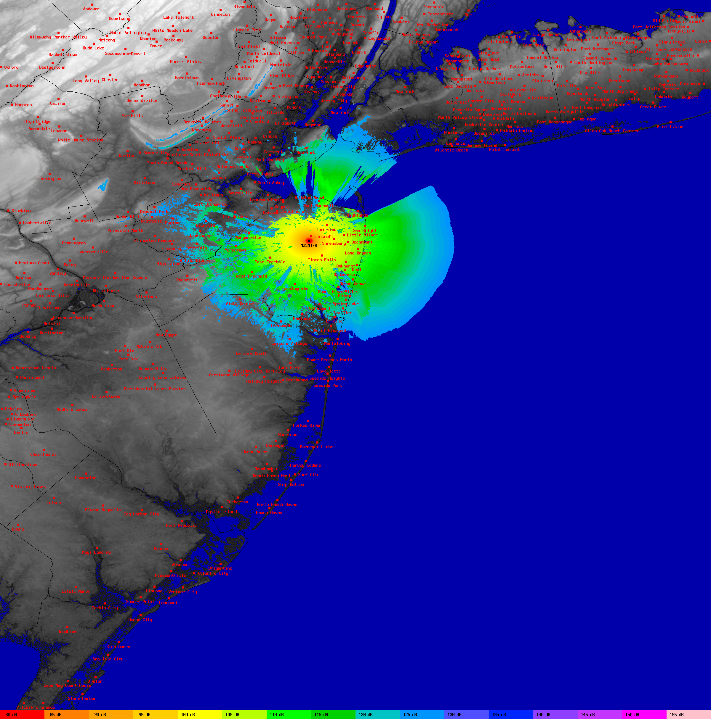
Figure 1 is a thumbnail representation of a much higher resolution (2400x2430 pixel) repeater coverage map generated by SPLAT! software. Each color represents a discrete level of path loss based on the Longley-Rice irregular terrain propagation model, assuming a frequency of 439.250 MHz, horizontal polarization, and a receiver antenna height of 30 feet above ground level.A legend at the bottom of the figure maps each color to a specific level of signal attenuation in dB. Effective coverage can be determined knowing the transmitter ERP, receiver noise figure, receiver antenna gain, frequency, bandwidth, and the minimum signal-to-noise ratio requirements.

Figure 2
In Figure 2, SPLAT! displays the line-of-sight coverage areas of four UHF-FM repeaters that are part of the W2NJR linked repeater system in New Jersey. Individual as well as mutual areas of coverage are clearly visible in this thumbnail image. Full resolution of this image is 3600x3600 pixels.
Figure 3
Figure 3 shows the line-of-sight paths between two transmitter sites and a common receiver site. In this example, the receiver is located 20 feet AGL in Oyster Bay, NY. The line-of-sight path between the Empire State Building and Oyster Bay is displayed in cyan, while the path between the Armstrong Tower in Alpine, NJ and Oyster Bay is displayed in green.Line-of-sight conditions are absent for either path. An antenna at least 95 feet AGL is required to reach the Armstrong Tower. At least 82 feet of altitude is required to reach the Empire State Building over a line-of-sight path.

Figure 4
Figure 4 illustrates a point-to-point path profile generated by SPLAT! Version 1.2.0. In this example, normalized terrain heights referenced to the line-of-sight path between two tower sites are plotted as a function of distance from the receive site on the left. This plot shows a line-of-site path unobstructed by terrain clearly exists between the Lincroft and Lawrence Township sites. In addition, clearance of the first Fresnel zone is demonstrated. The Earth's curvature contour against which the terrain has been plotted is displayed at the base of the plot.
Figure 5
WFUT-TV 68's directional contour is illustrated in Figure 5 using SPLAT! Version 1.2.0. Although transmitting from New York City, WFUT's signal is directed west northwest toward Newark, New Jersey, the station's actual city of license.Beginning with version 1.2.0, SPLAT! can generate KML files compatible with Google Earth when performing point-to-point analyses:

A line-of-sight path

Street-level path analysis

Predicted WNYE-DT signal strength contours with color key displayed in Google Earth (SPLAT! v1.4.0)
Google Earth's navigation tools allow the user to identify landmarks, roads, and other featured content.
In addition to graphic output, SPLAT! also produces data in the form of plain text. The following are a sample of some of the reports generated by SPLAT! software.

Custom Search
If you liked this article, subscribe to the feed by clicking the image below to keep informed about new contents of the blog:

About Hugo

RELATED POSTS

Matita interactive theorem prover (or proof assistant), a tutorial introduction: inst...

Jfractionlab educative program to practice fractions.

Jul 2014: 10 Most Popular Posts from Ubuntuland & The Dream Valley.

CaRMetal propose a different approach from the graphical interface point of view.

Tucnak is multiplatform VHF/HF contest logbook distributed under the GNU General Publ...

Xwota is intended for amateur radio operators who want to make use of the WOTA databa...

0 comments:
Post a Comment